Image: Early map
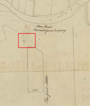
This extract from a 1792 plan shows the house of James Ruse as a small red rectangle near the northern border of the Experiment Farm grant. It was located to the north west of where Experiment Farm Cottage is indicated in Brownrigg’s 1844 plan, [Figure 3.12] and is close to Clay Cliff Creek, across which Hambledon Cottage was constructed in 1822. Between the house and the Barracks there is a pond. Near the river, were barracks, sufficient for one company, which were newly completed when Harris took up residence there in May 1791. Gardens were soon established in the vicinity of the barracks. The approximate location of the study area is indicated by the red rectangle. [PRO: CO 700 New South Wales 3, Plan and Survey of Parramatta and the Settlements in its vicinity, from the entrance of Port Jackson to Prospect Hill. Shewing the allotment granted to the First Settler. [Sydney]. MS. About 1000 feet to 1 inch. Part 3 of 4]